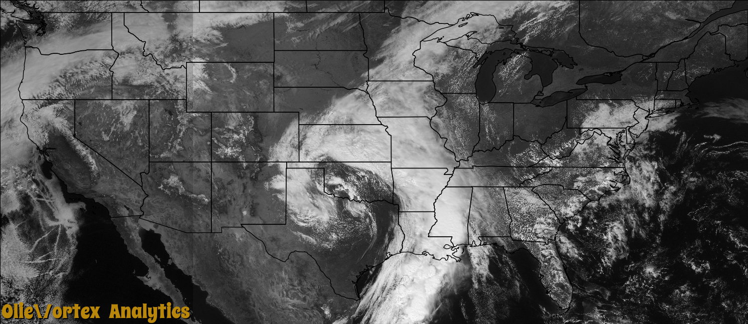
Tornado Reports
Sort by Time Sort by Rating Sort by State Sort by County| Time | Rating | Radar | State | County | Location | Narrative |
|---|---|---|---|---|---|---|
| 13:10Z | EF0 | KLIX | LA | St. Mary | Patterson | A large industrial warehouse had its garage door blown in, and several smaller neighboring storage buildings had minor damage with sheet metal peeled off the corners of the buildings. Across the street, sheet metal was pulled off an industrial canopy and debris was blown across Highway 90 into downtown Patterson. |
| 13:30Z | EF1 | KSHV | LA | Caldwell | Grayson | An EF1 tornado touched down in Caldwell Parish west of Grayson along State Route 845 snapping a few trees. The tornado moved north-northwest and intensified to EF1 intensity as it crossed Hwy. 126 and paralleled McCrary Road where most of the damage occurred. 20 homes were damaged and 1 mobile home was destroyed. The majority of the damage was due to falling trees as the area contained numerous large hardwood and softwood trees which were snapped or uprooted. Several outbuildings and sheds were also destroyed, primarily from falling trees. Other damage occurred to homes and structures along Hwy. 165 in Columbia area was due to straight line winds or rear flank winds east of the tornado track. |
| 14:34Z | EF1 | KLIX | LA | Ascension | Prairieville | A NWS storm survey team confirmed a tornado touched down and tracked through portions of Prairieville. The tornado initially touched down along Duplessis Road, tracked approximately 3 miles before lifting after crossing near the intersection of Highways 42 and 930. Several homes received significant roof damage and many trees were uprooted or snapped. The path width was approximately 50 yards with an estimated wind speed of 110 mph. |
| 14:43Z | EF1 | KLIX | LA | East Baton Rouge | Kleinpeter | Several trees were blown down and several homes suffered roof damage on Hoo Shoo Too Road. |
| 15:00Z | EF0 | KMHX | NC | Washington | Wenona | A very weak and brief tornado touched down near Wenona during the morning hours on March 21st. The tornado was spotted in an open field and did no damage. This tornado was not associated with a thunderstorm. These types of tornadoes are often referred to as dust-tube tornadoes or landspouts. |
| 15:05Z | EF1 | KLIX | LA | Livingston | Corbin | A weak tornado touched down just south of Varnado Road and tracked north-northwest across North Corbin Road. A home lost a portion of the roof and several trees were snapped along the track. The tornado lifted to the southwest of North Corbin Elementary School. The storm path length was approximately 0.5 miles, the path width 50 yards, and maximum strength EF1 with estimated winds of 100 mph. |
| 15:23Z | EF1 | KDGX | MS | Jefferson | Mc Nair | The tornado snapped numerous pine trees and uprooted oak trees over a rural part of the county. Maximum wind speed was estimated at 94 mph. |
| 15:51Z | EF2 | KDGX | MS | Claiborne | Willows | This tornado first touched down in northern Claiborne County downing trees along Floyd Road. It then crossed the Big Black River into southern Warren County impacting a hunting camp, destroying 2 mobile homes, snapping 4 power poles and snapping numerous trees. It then moved across Gullett Road where it destroyed 3 large outbuildings, heavily damaged the roof of a brick home, and snapped numerous trees. The tornado next crossed Campbell Swamp Road where it reached its maximum width and snapped hundreds of trees. The tornado then moved nearly parallel to Price Hill Road again snapping and uprooting many trees. One of the trees fell on a house causing significant damage. The tornado continued downing more trees, but then lifted as it crossed Jeff Davis Road. Maximum estimated wind speeds were 120 mph. |
| 15:54Z | EF2 | KDGX | MS | Warren | Allen | This tornado first touched down in northern Claiborne County downing trees along Floyd Road. It then crossed the Big Black River into southern Warren County impacting a hunting camp, destroying 2 mobile homes, snapping 4 power poles and snapping numerous trees. It then moved across Gullett Road where it destroyed 3 large outbuildings, heavily damaged the roof of a brick home, and snapped numerous trees. The tornado next crossed Campbell Swamp Road where it reached its maximum width and snapped hundreds of trees. The tornado then moved nearly parallel to Price Hill Road again snapping and uprooting many trees. One of the trees fell on a house causing significant damage. The tornado continued downing more trees, but then lifted as it crossed Jeff Davis Road. Maximum estimated wind speeds were 120 mph. |
| 16:11Z | EF1 | KDGX | MS | Warren | Stout | This tornado touched down near the Army Corps of Engineers Experimental Station where it peeled part of a metal roof off a building and overturned a trailer. The tornado then moved along Porters Chapel Road, where it knocked down trees and overturned a single wide mobile home. The tornado then weakened, but knocked down a few more trees in the Lakewood subdivision, causing some structural damage to a few homes. It lifted as it left the subdivision. Maximum estimated wind speed was 90 mph. |
| 17:16Z | EF0 | KLIX | LA | St. Tammany | Houltonville | A NWS storm survey team observed damage produced by a tornado northeast of Madisonville. The tornado touched down near the clubhouse in the Tchefuncta Country Club Estates neighborhood. The tornado continued on a path to the northeast, downing several trees and producing minor roof damage to two homes before lifting in a heavily wooded area beyond the neighborhood. The tornado had a path width of approximately 100 yards and a path length of one half mile. |
| 17:35Z | EF0 | KLIX | LA | St. Tammany | Abita Spgs | Weak EF0 tornado touched down near the intersection of Silver Springs Drive and Allen Road. It moved north, snapping several pine trees. Some roof damage was observed to one home where part of a tree had fallen through the roof. The tornado lifted after crossing Jarrell Road. Maximum estimated wind speed was 65 mph, maximum width 25 yards, and path length approximately 1.5 miles. Event time was based on radar. |
| 19:04Z | EF2 | KDGX | MS | Rankin | Gulde | The tornado started just north of Interstate 20 near Carter Circle where a few trees were uprooted. The tornado continued slightly west of north and remained relatively weak. It blew down a few trees and limbs along the path. The tornado intensified just after crossing US Highway 80 where it caused extensive damage to a large frame home. Most of the roofing structure of the home was destroyed, a back wall was partially collapsed and extensive shingle damage occurred to the remaining roof. In addition, along the narrow path of the tornado, rather intense tree damage occurred north of the home with a number of large trees uprooted and snapped. From this point the tornado continued northward over Pelahatchie Creek and then crossed Lake Road in two spots, snapping and uprooting a number of trees along its narrow path. The tornado continued across Haynes Chapel Road snapping several trees. The tornado dissipated between Haynes Chapel Road and Holly Bush Road. Maximum estimated wind speeds were 115 mph. |
| 21:00Z | EF0 | KDGX | MS | Forrest | Dragon | The tornado began off of Longleaf Drive with a couple of softwood trees snapped. One tree fell on a fence and damaged it. The tornado continued north to Eastabuchie Road, where a few more trees were snapped and a few shingles were torn off a roof. It crossed Eastabuchie Road and ended just north of the road snapping a few more trees. Maximum estimated wind speeds were 85 mph. |
| 22:31Z | EF0 | KDGX | MS | Jones | Reddoch | There was a brief tornado touchdown at a chicken farm on Huey P Road which caused heavy roof damage to one chicken house and uprooted a tree. Maximum estimated wind speed was 75 mph. |
| 01:32Z | EF0 | KLIX | MS | Harrison | Ligana | A NWS storm survey concluded that an EF0 tornado with a path width 50 yards wide was on the ground for about one quarter mile. Winds were estimated at 70 mph. Damage was confined to a trailer at Vidalia and Walnut Roads. |
| 02:03Z | EF0 | KDGX | MS | Jasper | Paulding | This tornado snapped and uprooted a number of trees along a narrow path along County Roads 16 and 503. Maximum estimated winds were 75 mph. |
| 05:35Z | EF1 | KMOB | MS | Harrison | Wool Market | NWS Storm survey confirmed a tornado touched down on John Lee Road and Roberts Road. Trees were twisted, a travel trailer was flipped, and several homes lost portions of their roofs. The path width was 100 yards, and was on the ground for nearly 1 mile. Estimated wind speed was 90 mph. |
| 10:10Z | EF0 | KMOB | MS | Harrison | D Iberville | NWS storm survey confirmed a tornado touched down along Highway 67 at Highway 15. Most of the damage was at the starting point with a large shed door blown in, causing roof damage and a patio roof lifted off. Most of the remainder of the damage was to shingles and fences, with an end point in Coventry Estates. The path width was 100 yards with a damage track around 4 miles long. Estimated wind speed was 85 mph. |
Storm reports are derived from "The Storm Events Database" (National Centers for Environmental Information) and/or "Past Storm Reports" (Storm Prediction Center).