Tornado Reports
Sort by Time Sort by Rating Sort by State Sort by County| Time | Rating | Radar | State | County | Location | Narrative |
|---|---|---|---|---|---|---|
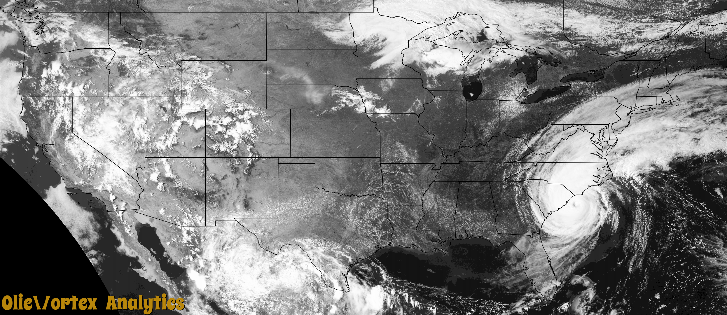
| 13:02Z | EF2 | KMHX | NC | Carteret | Cape Carteret | A waterspout near Bogue Inlet Pier came onshore as a tornado near|Janell Ln., Boardwalk RV Park and Salty Pirate Waterpark in Emerald|Isle. The waterspout was quite large when it was offshore and was |viewed by the Bogue Inlet Pier web cam courtesy of Surfline. The |most intense damage was found here. On Janell Lane, a |section of a metal roof was removed on one side of a house that was |in the opposite direction of the storm motion. On the other side of |the house, with the storm motion, large sections of the metal |roof were removed with similar damage to a house next door. As the |path crossed into the RV park, numerous RV style homes were tossed |and rolled more than 30 feet, ripping out ground anchors that |strapped them down. ||In the middle of the path, where the winds were strongest, numerous|RV type homes suffered complete destruction. Based on the complete|destruction of the homes, along with the loss of substantial sections|of a metal roof, which usually have a higher wind rating, damage was|consistent with that of an EF 2 tornado or around 115 MPH.||The path continued to the north northwest where more damage was |found to the Salty Pirate Waterpark and continued across Highway 58 |(Emerald Drive) where several homes were damaged along W Harbor Trail |and Sunrise Ct. The tornado then moved over the Bogue Sound, |becoming a waterspout again. Eyewitness accounts indicate that a |funnel may have persisted, but no apparent tornado damage was |found in Cedar Point. ||Several videos from members of the public conclusively show that the |funnel cloud returned to the surface in the form of a waterspout as |it crossed over the lower White Oak River. The waterspout continued for |several minutes northwestward up the White Oak River before once |again coming ashore as a tornado and causing major roof damage to a |home on Watersedge Cir. and minor damage to several other structures |in the Holland Point Dr. area. ||The tornado then tracked through mostly forested and undeveloped |land for approximately 6 miles before heavily damaging a farm and |residential property on Kidd Ln. in Maysville. Based on eyewitness |accounts, the funnel cloud may have persisted for several more |miles, but the lack of identifiable tornado damage indicates that |the end of the tornado path was this location on Kidd Ln. in southern |Maysville. |
| 15:48Z | EF1 | KLTX | NC | New Hanover | Kirkland | A waterspout moved ashore over the northern end of Figure Eight|Island, causing EF0 damage to a couple beachfront homes and trees.|The tornado track was evident across the marsh towards the|Intracoastal Waterway, where it affected Bald Eagle Ln. At the|Bald Eagle Ln area there was one injury, numerous trees snapped|and uprooted, along with mostly minor home damage. The tornado|moved northwest towards Fazio Dr where it created its widest|damage, including some roof damage and large trees snapped near|the Porter's Neck golf course. The tornado continued to move|northwest to Futch Creek Rd and Plantation Landing Dr where it|lifted after producing EF0 damage, mainly to trees. |
| 16:19Z | EF1 | KLTX | NC | Pender | Clarks Lndg | A tornado formed near Forest Lane, where several large tree|branches were broken. The tornado continued off to the northwest,|where EF0 damage was also seen at Clarks Landing Loop Rd due to |several snapped trees near a field. Low-end EF1 damage was then |observed on Long Creek Loop Rd where softwood trees were snapped.|The tornado continued off to the northwest where damage was |limited to broken tree limbs, before lifting near Herrings Chapel|Rd and Mulberry Ln. |
| 16:37Z | EFU | KRAX | NC | Lenoir | Deep Run | NC highway patrol reported a tornado briefly touched down. |
| 17:10Z | EF0 | KLTX | NC | Pender | White Stocking | A tornado was likely already occurring as it moved into the old |Maple Hill Rd area south of Highway 53 causing trees to be |snapped. Prior to this time, it was likely over the Holly Shelter|swamp area which was unaccessible during our damage survey. The |tornado moved WNW, crossing Shaw Highway near Old Blakes Bridge |Rd. causing some minor tree damage. The tornado then crossed |Highway 53 causing additional tree damage. The tornado finally |lifted near Croomsbridge Rd north of Highway 53 in the Shelter |Neck area. |
| 17:52Z | EF0 | KRAX | NC | Wayne | Genoa | An EF-0 tornado briefly touched down in Mar-Mac, Wayne County, North |Carolina. The impacts consisted of shingle and siding damage to several homes, numerous large hardwood trees that were uprooted, a trailer that was rolled over, |and a pickup truck that was tossed several yards. This tornado occurred |in an outer rain band associated with Hurricane Dorian. |
| 18:30Z | EF0 | KMHX | NC | Craven | Vanceboro | The tornado started near the intersection of Gray and Lewis Road, and|moved off to the northwest where trees were down on Kite Town Road. The|sporadic path continued northwest across Wilmar Road before ending in a|field. The damage consisted mainly of uprooted or snapped trees with |estimated top winds of 75 mph. We thank Craven County Emergency Services|for the help with this tornado survey. |
| 20:07Z | EF1 | KRAX | NC | Wilson | Holdens Xrds | An EF-1 tornado briefly touched down 3 miles northwest of Saratoga, |Wilson County, North Carolina at 4:07 PM EDT. The impacts consisted of numerous very large hardwood trees that were uprooted, some with trunks that were snapped, and an outbuilding that was completely destroyed. The survey team also |noted a field of corn that was flattened in a circular fashion. |This tornado occurred in an outer rain band associated with Hurricane |Dorian. |
| 20:31Z | EF0 | KRAX | NC | Johnston | Smithfield | A weak EF-0 tornado very briefly touched down in Smithfield. Damage consisted of |at least one very large Oak tree that was uprooted and blown down |onto a home. In addition, numerous other large tree branches and |several smaller trees were snapped and uprooted. This tornado |occurred in an outer rain band associated with Hurricane Dorian. |
| 21:00Z | EF0 | KMHX | NC | Craven | James City | A tornado touched down briefly near City Hall in downtown New Bern. Damage was primarily concentrated near the intersection of Pollock and Craven Streets. The damage was mostly minor consisting of numerous smaller limbs that were snapped along with a trash can blown over. Along Craven Street, a larger part of a tree was broken along with some damage to an awning. Top winds of around 65 mph were estimated. |
| 04:38Z | EF0 | KAKQ | NC | Perquimans | Parkville | A weak tornado tracked through farmland leaving a well defined track in the field near Four Mile Desert Road. |
| 04:44Z | EF0 | KAKQ | NC | Perquimans | Belvidere | A weak tornado damaged three chicken houses and several other outbuildings near Belvidere Road. |
Storm reports are derived from "The Storm Events Database" (National Centers for Environmental Information) and/or "Past Storm Reports" (Storm Prediction Center).